 |
| Home | Geography | History | Biology | Recreation | News | Resources |
| Farming |
Meetinghouse Hill IndexThis page is an overview and index to the pages on this website relating to Meetinghouse Hill. Each page provides detail on an aspect of the story with documentation. It was used in support of the effort to save Meetinghouse Field from development. As it was developed over a period of time there is some duplication of content. The buildings were historically written as two words - 'meeting house.' However the hill in Vernon on which the meeting house was located is commonly referred to in documents of the time as 'Meetinghouse Hill. Read the narrative version of the Story of Meetinghouse Hill.
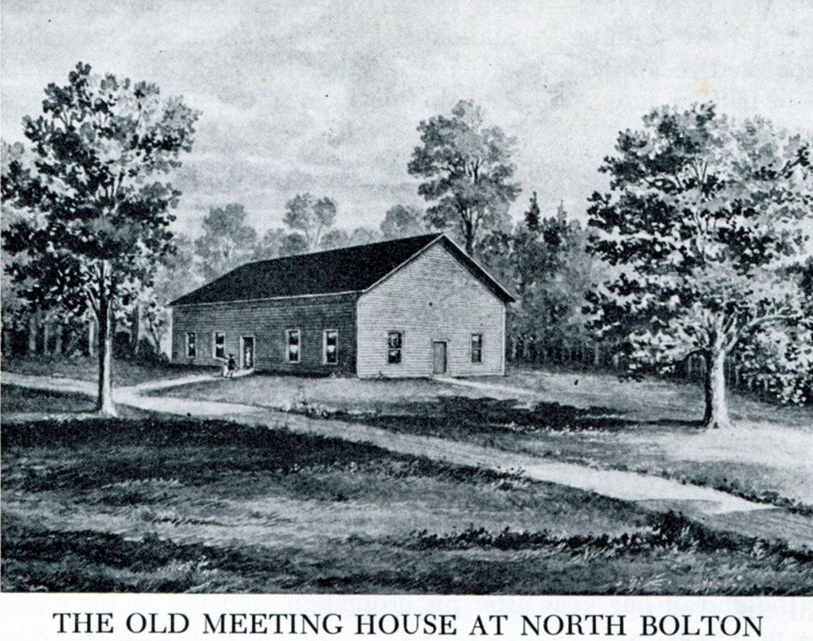
When Vernon's early settlers received permission in 1760 to establish the parish of North Bolton they immediately began planning their meeting house. In Eighteenth Century Connecticut there was no separation of church and state so the meeting house would serve as their church, government and social center. The location chosen was on the old Indian trail that had become the main east-west road through the parish. The preferred location for meeting houses was on a hilltop and this one overlooked the Connecticut River Valley such that on a clear day the mother church in Hartford was visible. The site was also close to the only cemetery in the area on today's Bamforth Road. » Go to Vernon's First Meeting House At this time roads were undeveloped with most families walking to church. The road they took to church each Sunday for 63 years climbed what came to be known as Meetinghouse Hill. Where it passed over a small brook a bridge was built of fieldstone to accommodate travelers. » Go to Meetinghouse Hill Field The road to Hartford became an official turnpike in 1801 and with subsequent improvements was straightened bypassing Meetinghouse Hill. When the new church at Vernon Center was built in 1826 the road up Meetinghouse Hill, still unpaved, was abandoned by the town. » Go to Meetinghouse Hill Path What was now called Old Meetinghouse Hill returned to use as a farm field. The Strong family bought the field with its red barn in 1900. It had been allowed to deteriorate but the Strong's drained the wetlands, improved the pasture and used it primarily for their herd of dairy cows, which were moved from the field to the farm for milking each day for over a hundred years. » Go to The Barn At Meetinghouse Hill When Norman Strong died in 2010 this part of his Heritage Farm was left to his heirs in the Strong Family Trust. In 2014 the Trust decided to sell the fields. To preserve this important piece of Vernon's heritage, and one of the last reminders of our agricultural heritage, the community raised $1,000,000 in grants and community donations, purchased the 33-acre property with another 18-acre field on West Road and returned it to the Strong Familly Farm, LLC. The development rights are held by CT Farmland Trust such that the field can only be used for agriculture. The fields are also accessible for walking by town residents and future generations.
The story of Meetinghouse Hill is forgotten or was never known by most people in town. But it reminds us of where we came from, where we are today, and what we want to preserve for tomorrow. Updated March 2021 |
Home | Activities | News | References | Search | Site Map | Contact Us © Copyright The Tankerhoosen. All rights reserved. |