 |
| Home | Geography | History | Biology | Recreation | News | Resources |
| Rockville |
Rockville's Early Water SystemFor most of the twentieth century a pair of standpipes stood atop Stickney Hill in Rockville providing high pressure water to the city below for factories, homes and fire department. Although gone now they were an important piece of Rockville's history helping to make the city as prosperous as it was. This is the story of Rockville's early water sysem.
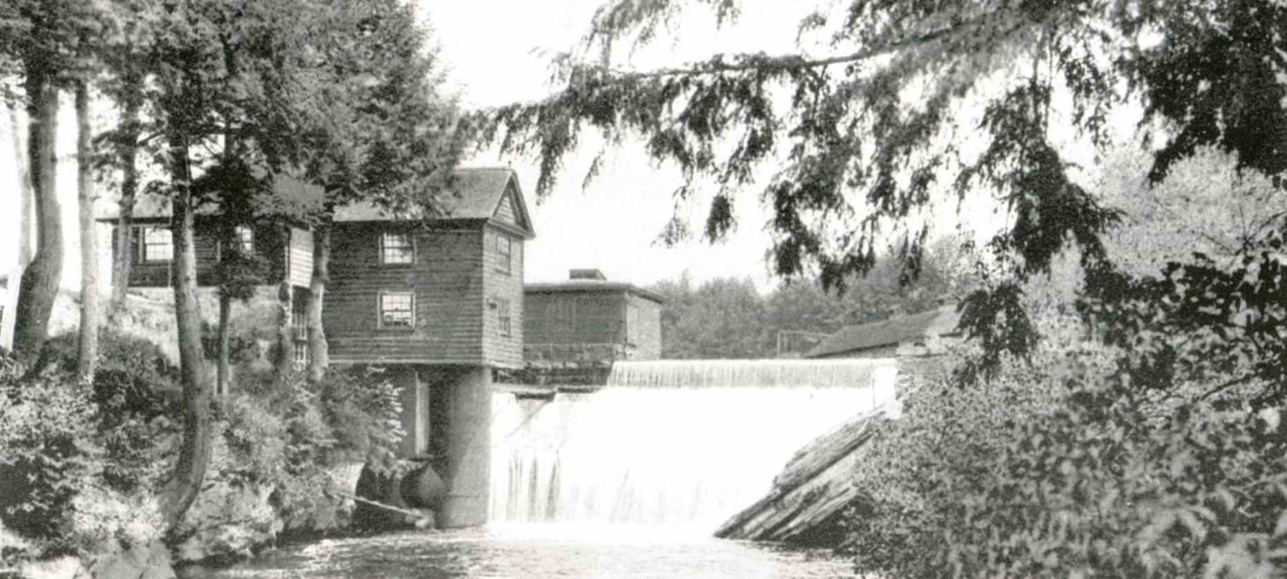
Large mills came to the Rockville area in the 1820's, with the first power looms at Rock Mill in 1821. What attracted them to the upper Hockanum Valley was Shenipsit Lake, which provides a large and consistent flow of water. Growth of the city was steady and expanded significantly in the late 1840's. At this time each mill was an independent fiefdom providing housing and services for its mill and employees. Mill owners cooperated to control the flow of Hockanum River water to the mills ensuring they could all thrive. However, as manufacturing waste was dumped into the river it was not safe for other uses. As the area grew the need for a clean supply of water for factories as well as domestic uses and fire protection became evident. In 1834 a group of mill owners formed the Rockville Manufacturing Company and purchased Payne's Mill and the Shenipsit Lake dam. They erected a three and a half foot stone and gravel dam and began selling water to parts of Rockville. In 1847 The Rockville Aqueduct Company was organized by the mill owners and the Shenipsit dam was raised by 10 feet. This was for two purposes: to protect water rights along the river, and to bring water to more homes. The company built a gravity system that began service that same year using cement-lined wrought-iron pipes. The company's first main was an 8-inch cement pipe. The first line of pipe came down to what was then a reservoir basin in Central Park. This reservoir basin supplied the lower part of the village.
In 1863 the railroad spur from Vernon Depot to Rockville opened leading to additional growth in the area. Just from 1858 to 1871 the population grew from 500 to 4,500. The limited resources of the water company were unable to meet the demands of local residents, leading to the reorganization and incorporation of the Rockville Aqueduct Company in 1866 "for the purpose of supplying the village of Rockville, in the town of Vernon, with an abundant supply of pure water for public and domestic use." It was said the supply of water was equal to the demands of a population of 40,000. Cast-iron pipes were installed as the wrought-iron pipes had not worked well. They now were able to pipe running water into the mills and the homes of 250 families and the installation of 36 new fire hydrants provided greater fire protection to the crowded village. A 12-inch cast iron main was laid in place of the 8-inch main. Service pipes were of lead and wrought-iron. Lead pipes can cause physical and behavioral damage, especially in children. It is unknown how long the pipes were there. Hopefully by now they have all been replaced. Rockville was incorporated as a separate entity in 1889 and the Rockville Water and Aqueduct Company was incorporated in 1893 merging the Rockville Aqueduct Company and the Rockville Water Power Company. Previous to the consolidation, the Rockville Water Power Company had to do largely with water for power purposes, while the Rockville Aqueduct Company was interested principally in water for domestic purposes. In 1893 and 1894 a 20-inch cast iron main was laid, which extended as far as the corner of West Main Street and Vernon Avenue. Prior to 1894 the high pressure service was supplied by wells and cisterns.
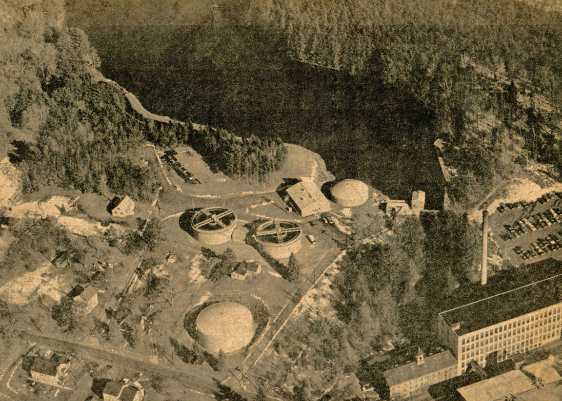
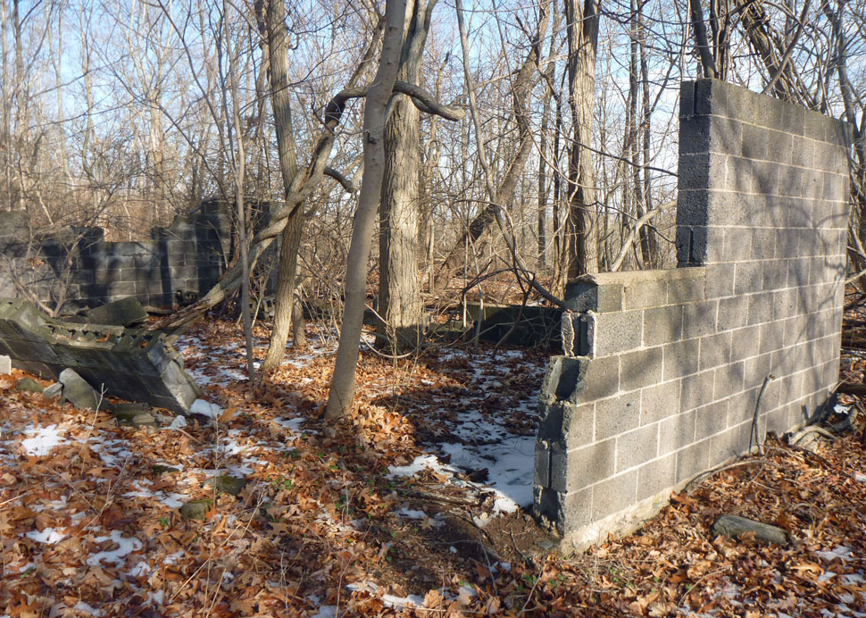
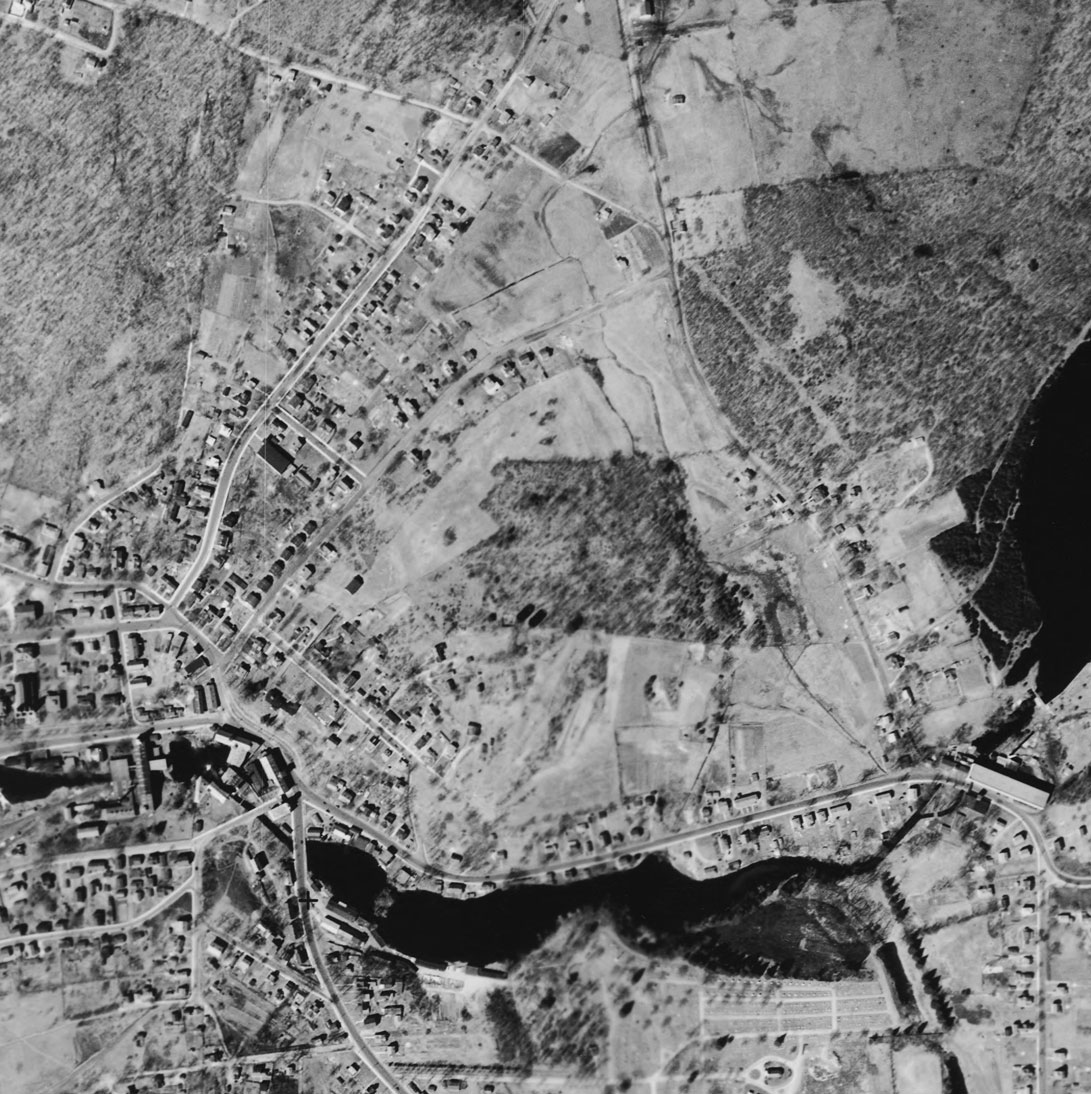
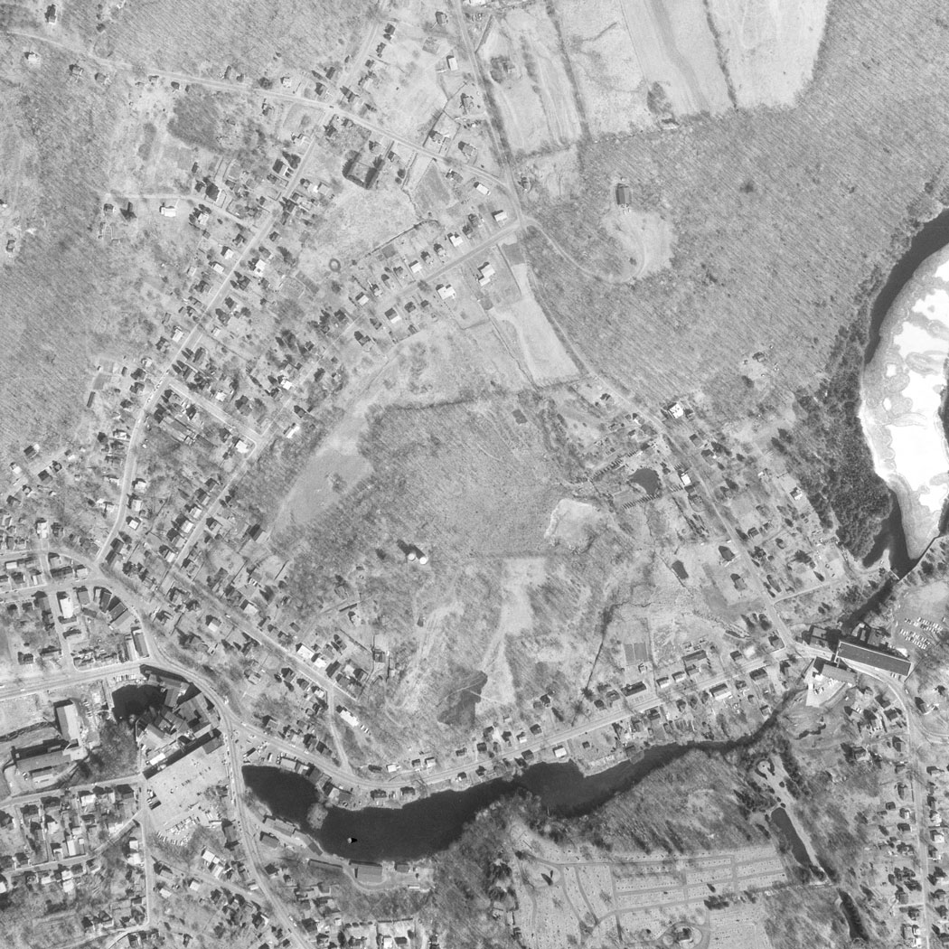
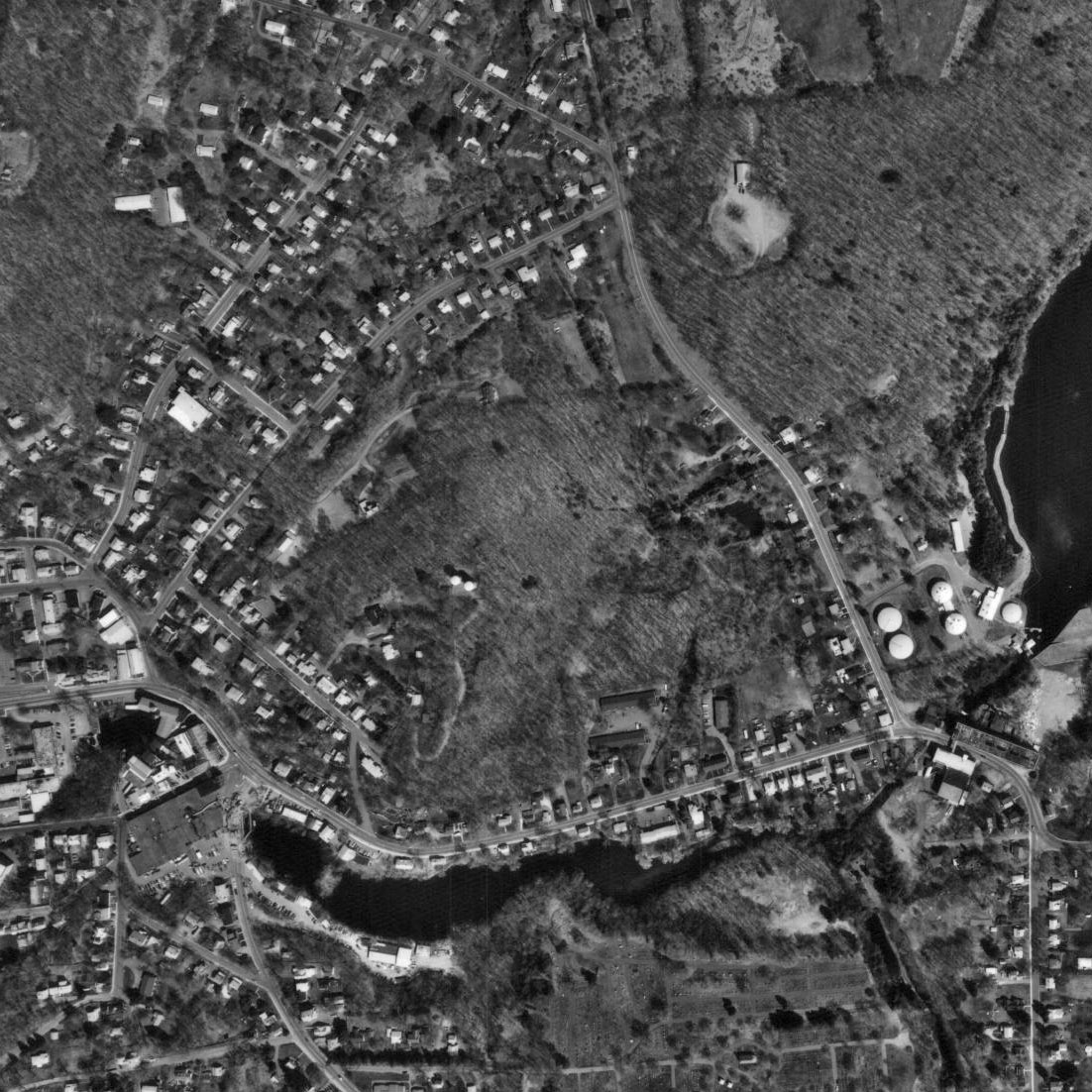
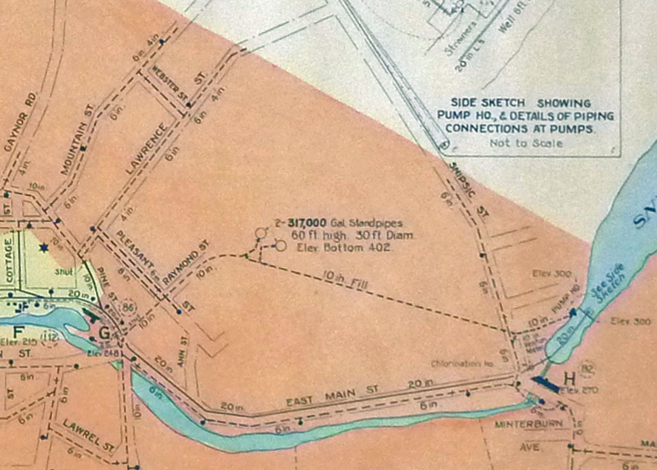
Although the use of elevated water storage tanks has existed since ancient times in various forms, the modern use of water towers for pressurized public water systems developed during the mid-19th century as steam-pumping became more common and better pipes that could handle higher pressures were developed. Very high volumes and flow rates are needed when fighting fires. With a water tower present, pumps can be sized for average demand, not peak demand. A water tower can provide water pressure during the day and pumps will refill the water tower when demands are lower. Rockville's pumping station and standpipes were installed in 1904. A cement block building was also located on the site which likely protected controls and gauges. It may have been serviced from a path off Raymond Street or from a dirt road at the end of Pleasant Street. The 1937 Public Water System map of Rockville describes the pumping station at Shenipsit Lake and flow throughout the city, including the two standpipes on Stickney Hill. The standpipes are described as 30 feet in diameter and 60 feet high with a capacity of 317,000 gallons each at a base elevation of 402 feet. The pipes were 10 inches in diameter. Pumped to the top of the hill gravity did the rest as needed. The Connecticut Water Services Company acquired a majority of the stock of the Rockville Water and Aqueduct Company in 1957, and in 1974 the Connecticut Water Company acquired the Connecticut Water Services Company, which shared common management. We don't yet know when the standpipes were removed. A 1984 topographical map shows the towers in place and they are visible the 1995 aerial map. Today remnants of the building remain, but little else. The three aerial photos taken 30 years apart show the standpipes or their shadows. The photos also show how this section of Rockville changed over the 60 years. For much of the time sections were farmed, now it is second or third growth forest.
The Pipeline
The MLCT property has a jagged shape. Although there are survey pins here and there its challenging to determine the location of boundaries. The trust is currently planning trails and exploring the property. One of the questions to be resolved is exactly where was the pipeline and would the pipeline make a good path? A survey map done for Lee & Lamont in 2009 provides detail and the name of abutters. The Connecticut Water Company owns what appears to be an inaccessible, roughly 100 x 200 foot, property where the standpipes stood. This might be located by the remains of the cinder block building. From there the pipeline runs roughly Southeast to the pump station. The CT Water Company has an easement along the line. Today's Google and Bing aerial maps show little, but the 1934, 1965 and 1995 aerial maps are more interesting. The two standpipes (or their shadows) are clearly visible. At various times the southern half of the property was clear of trees and parts of it appear to have been farmed. The northern section is tree covered. The intersection of the two pieces is a straight line about where the pipeline would have been. It will be interesting to see if there is a difference today in tree size in that area. SourcesNote: Shenipsit Lake has had many spellings on maps and in documents over the years. I found Snipsic, Snipsick, and Shenipisit in various places. First spelling of the current version was on the 1857 Tolland County map. Snipsic was used as late as 1937 on town documents. McKenzie, William Neal (1973). Remarks on Early History of the Company. 17 pages. An address by the Rockvile Water & Aqueduct Company President to the New England Water Works Asso. Detail history of Rockville water works development. Smith, Harry Conklin (1911). A Century Of Vernon, CT 1808-1908. This appears to be an addition to Smith's 1908 town history discussing ?Vernon and her Industries.' Smith was the editor of the Rockville Leader. The entire text can be found online. Symonds, Jr, Richard N. (2006). Historical Guide to Ponds, Dams, and Mill Sites in Tolland, Connecticut. Includes information on Shenipsit Lake. Documentary History of American Water-works - Website; includes references including incorporation papers and listings from 1880's "Manual of American Water Works." General History of Water Towers - Wikipedia entry. Updated March 2021 | ||
Home | Activities | News | References | Search | Site Map | Contact Us © Copyright The Tankerhoosen. All rights reserved. |