 |
| Home | Geography | History | Biology | Recreation | News | Resources |
| Activities | Trails | Places |
Scenic Views
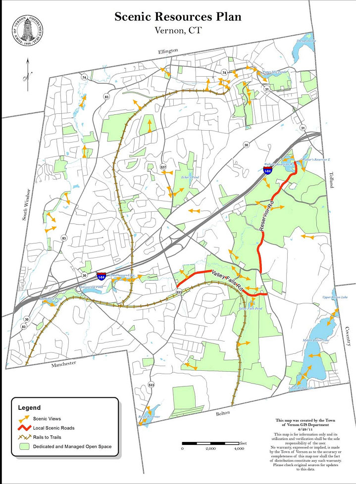
Tucked into documents published by the town or in grant reports are tables and maps that few see, but include great information. One such map is included in the 2012 Plan of Conservation & Development. A map called 'Scenic Resources Plan' that was created by the Town of Vernon GIS Department in June 2011 shows the best Scenic Views in town as well as local Scenic Roads. Additional Scenic Roads have been added since the map was created, but the Scenic Views encourage exploration. The map also has a nice layout of the Rail Trail and Vernon's Open Space land. Scenic Views and Roads are considered part of Vernon's unique character and the POCD encourages us to limit the type of development and building coverage allowed in areas with hills and hilltops, as well as limiting the clearing of trees during the development review process. Examples of poor public planning are blocking public access to the scenic views on Zoey Drive and Boxwood Drive. Click the map to see the larger, more detailed pdf document. Tankerhoosen Valley Scenic ViewsEighteen of the mapped scenic views are within the Tankerhoosen Valley. The following list begins at Walker Reservoir at the east end of the valley and works south and west to Talcottville. Click on the name to see a photo of the view. Links are also included to pages with more information on the area. Walker Reservoir East: The view is south from the parking lot of Reservoir Road looking across towards the dam. Walker Reservoir West: The view is west from the Shenipsit Trail behind the Soldream, Inc. building. Tankerhoosen Wildlife Management Area: The view appears to be south from I-84 between Bamforth Road and Exit 67, but could also be from the Shenipsit Trail in that area overlooking the old gravel pit. Tankerhoosen River Falls: The view is east just up river from the point it crosses Reservoir Road. Prettiest natural falls on the river. More about the Tankerhoosen Wildlife Management Area. Tankerhoosen River: The view is west from the point it crosses Reservoir Road. Tankerhoosen Valley: The view is west from Zoey Drive off Dockeral Road and overlooking Vernon and the Connecticut River Valley. Great panoramic view but privately owned. Valley Falls Farm: The view is west from Bolton Road at Valley Falls Road. Valley Falls Pond: The view is south from the parking lot. Valley Falls Cliffs: The view is east from the cliffs above the Rail Trail across Valley Falls Park. Belding Wildlife Management Area Pond: The view is west across the pond. Belding Wildflower Meadow: The view is northwest from Bread and Milk Road. More about the Belding Wildflower Meadow. Bread and Milk Road: The view is east across the meadows. Valley Falls Road: The view is northwest near Valley Falls Road Cemetery looking across the fields. Strong Farm: This is not the farm itself but a field owned by the farm. The view is west from Boxwood Drive across the field between Route 30 and Cemetery Road. Nice view but only for the homeowners. The photo is from Cemetery Road. Tankerhoosen River From The Rail Trail: The view is east from the Rockville Rail Trail spur where it crosses the river. Tankerhoosen Lake: The view is west from the Rockville Rail Trail spur where it crosses the river. Phoenixville Dam: The view is east from Phoenix Street of the Tankerhoosen Lake dam. More about Phoenixville. Talcottville Pond: The view is east near the entrance to the NCLT's Talcott Ravine at the end of Main Street. More about the Talcott Ravine. |
Home | Activities | News | References | Search | Site Map | Contact Us © Copyright The Tankerhoosen. All rights reserved. |